Emigrant Lake
- A classic suffer fest as Pepper and I scout the Emigrant Wilderness from Kennedy Meadows.
This was a scouting trip for a planned packing trip later in the summer. I am very glad I scouted it out, we ended up scrapping the trip. My planned itinerary would not have been pleasant. I had planned on a base camp at Sheep Camp, which is a nice open spot with access to the river, but it would have been too much to get to even as a day hike and would have left quite a bit still to get up and over either pass and into the beautiful sections of backcountry wilderness there. If I can figure out how to get everyone happily over to Emigrant Lake, that would be an incredible destination.
DAY 1
 |
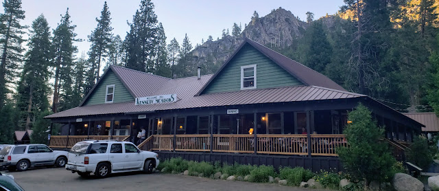
| Kennedy Meadows Lodge packed with north bound PCT hikers |
Day 1 Highlights
- Temps hit 109 driving through central valley. Had a great stop at the Strawberry General Store to grab dinner and a few other snacks.
- The very first 3 to 4 miles hiking up to Relief Reservoir are extraordinary. You hike among giant sugar pines, along trail carved through rock overhangs and over bridges spanning roaring rivers.
- Kennedy Meadows Lodge was not a welcoming place. I ended up dropping my pack near the trailhead, then parking a mile back down the road at the National Forest overnight parking lot. This definitely contributed to my decision to cancel our pack trip we had planned for later in the summer.
- Found a great campsite 3.3 miles in (and over 1,000ft elevation gain), near an old mine, once it started to get dark.
DAY 2
 |
| Morning light looking back towards Kennedy Meadows |
 |
| One of many wildflowers |
 |
| Relief Reservoir |
 |
| Brown Bear Pass and views into northern Yosemite |
 |
| Idyllic Blackbird Lake |
 |
| Granite cliffs welcoming you to magnificent Emigrant Lake |
Day 2 Highlights
- Over 13 miles and 2,400ft elevation gain to scout out the loop over Brown Bear Pass. Brought my pack with me as I hadn't really hiked in enough to make a day trip out of the loop.
- Had several pauses for thunderstorms. One break was under the shelter of pines among the soft, dry needles. Another was in the tent among the rocks far from Middle Emigrant Lake.
- Saw several pack trains heading up to the passes, but no other hikers after Sheep Camp.
- The trail disappeared at Emigrant Meadow Lake among the bogs and dense clouds of mosquitoes. Reappearing only now and again until Blackbird Lake.
- Watched a bald eagle soar over Emigrant Lake as I stopped at the crossing of the North Fork of Cherry Creek where it flows into the lake. It is a sandy spot at the river bank where the water spreads out. There were trout swimming and flashing their bright colors as they jumped for bugs.
DAY 3
 |
| Sunrise on Emigrant Lake |
 |
| Arriving at Mosquito Pass |
 |
| Reflections at Mosquito Pass |
 |
| Post-Gatorade glow and tired Pepper, safely back in the car |
Day 3 Highlights
- Over 14 miles, with 700 feet of gain and over 3,000 feet of descent. This was brutal as I was feeling the full effects of covid and wanted to try to get back home at a decent hour. I went very slowly up to Mosquito pass, meeting with only one other hiker who had also stayed at Emigrant Lake. Once I got over the pass and down to lower elevation, with many snack breaks, I felt much better and was able to pick up the pace and get back safe.
- Lots of hikers once I got closer to Relief Reservoir. Some heading into and some heading out of the wilderness.
- Pepper did great - the only parts she didn't really like were the shadeless trail sections later in the day.
RECAP
- Location: Emigrant Lake, Emigrant Wilderness via the Kennedy Meadows trailhead.
- Date: June 2022.
- Stats: 31+ total mileage with ~7,200ft elevation gain.
- Maps: NatGeo 807 Carson-Iceberg, Emigrant and Mokelumne Wilderness Areas. Emigrant Lake USGS Quad. Emigrant Wilderness permit self issued at the Summit Ranger station in Pinecrest.
 |
Route map
Gaia GPS | © OpenStreetMap Contributors |
Some high highs and low lows - glad we made it back safe!


No comments
Post a Comment